Orrin Smith and I went to Box with pilot Greg Porter, who drove down from Phoenix offering to drive for us! Also along were Orrin's son Taylor and his friend ???.
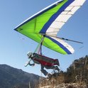
When we got to Box it was blowing in nicely. By the time we got set up and ready to go it was 2 PM. Orrin was first, flew right at launch level but found a small-ish thermal to the right (north) of launch and started getting up.
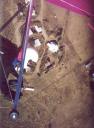
A short while later I took what looked like a nice cycle, but it didn't work out for me. I found myself sinking almost immediately, and turned to head for the bailout LZ. I found nothing but sink, came up about 500' short of the LZ, did a poor job of landing in the trees and cactus, and broke my poor Sport's keel. I also fell onto a sharp rock, ripping a hole in my chute container, deployment bag and tearing my reserve chute. No injury, I was lucky, but I sure have a lot of repairs to do.
While Greg and the kids drove down to retrieve me, Orrin got high and headed over the back. By the time I was back in the truck he had made it across the Sonoita valley, over the Stones and past St. David. Greg had loaned Orrin a cell-phone tracker and we were able to watch his progress on the instamapper.com web site. Orrin got as high as 13000 but spent quite a bit of time a few thousand over. We saw him fly toward Cochise Stronghold, but then fly back toward landable terrain as he got low.
He landed about 12 miles east of St. David along Horse Ranch road, which has a couple of locked gates. We lucked out and met a resident shortly after arriving there who let us follow him back through the gates, and we finally located Orrin around 6 PM. Even with the back-track he had managed 41 miles, a terrific flight.
John
Box Canyon report
Moderators:ioan, John Wolfe, aaroncromer, jlowery
-
Greg Porter
- Posts:9
- Joined:Mon Apr 09, 2012 7:37 pm
-
Tom Morrison

- Posts:38
- Joined:Mon Jul 20, 2009 6:25 pm
- Location:Ottawa, Ontario, Canada
-
Eric Tucker
-
Greg Porter
- Posts:9
- Joined:Mon Apr 09, 2012 7:37 pm

-
Greg Porter
- Posts:9
- Joined:Mon Apr 09, 2012 7:37 pm
Morey, per Google Earth its right at 30.3 miles to the center of the Ft Huachuca runway. So how long ago was that and were there any issues with flying into their airspace, which it looks like they control for a 5 mile radius from 7200 MSL to the surface? 30 years ago we had no restrictions at South Mountain / Sky Harbor. I had DC10's go by below me setting up to land...
Greg Porter
Mesa, Az
602 571 16seven4
Mesa, Az
602 571 16seven4
Ack. No- I didn't land at Libby Field! I said Ft. Huachuca, but I really meant Whetstone. It's not even an airport. there was a little uncontrolled landing strip east of Whetsone somewhere that I found. Good LZ's suck me in. I don't like surprises.Greg Porter wrote:Morey, per Google Earth its right at 30.3 miles to the center of the Ft Huachuca runway. So how long ago was that and were there any issues with flying into their airspace, which it looks like they control for a 5 mile radius from 7200 MSL to the surface? 30 years ago we had no restrictions at South Mountain / Sky Harbor. I had DC10's go by below me setting up to land...