REVSION DATE: 12/21/2024
Overview
The Whetstone Mountains are a hang gliding site located East of Sonoita on the southern face of the range, and can be flown year-round. The Whetstones are a dry and rugged fault-block mountain range only about 15 miles long. The upper slopes support open oak-juniper woodland; the lower slopes are scrub-grasslands.
The only access to this mountain range is by a few unimproved four-wheel drive routes that reach some of the lower canyons. There are no roads reaching higher elevations. A single hiking trail into the heart of the mountain range is accessed from Kartchner Caverns State Park (a visit to the Caverns is worth it if you have the time).
Site Requirements
- Current SAHGA (or AZHPA) and USHPA memberships.
- Local guide required for all pilots new to the site.
- H4 rating.
- CAUTION: Read all the general requirements and warnings here.
Skill Requirements
- FSL, TUR, XC, RLF
- This is a flat-slope launch best flown in strong SW conditions.
- 15mph min, 20mph max, 18mph ideal, gust limit 5mph
- Wind Direction in tables below listed in compass degrees
- Ideal
-
OK
Know Before You Go
- Suitable for HG only.
- A local guide is necessary to access the launch.
- This is a flat-slope launch best flown in strong SW winds
- Requires a hike of 160’ vertical over 0.25 miles.
- The primary LZ is adjacent to a ravine
- Shallow-slope launch, 360’ vertical above LZ.
- This site is difficult to access,remote, and primitive in nature
Site Description
- Season: Year-round
- Land ownership: Coronado National Forest.
- Driving directions: Contact a local guide.
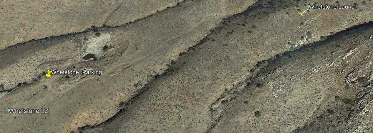
Parking
- Very limited. No more than two vehicles at the LZ and no more than one vehicle at the trailhead.
Facilities
- None at the LZ or launch. The nearest restrooms are in Sonoita.
Launch
- Elevation: 5,940’
- Coordinates: 31.768147, -110.458351 (Google Maps link)
- Orientation: SW
- Type: Shallow slope
- The hillside is somewhat rocky. Clearances are not a problem, but desert flora (century plants and cactus) may present a hazard in the event of a failed launch.
- HG Winds: 15-20 mph, max gust 5 mph over 5 seconds
- Wind direction: “Go” 230°-255°, “Caution" 220°-265°
- Setup area: Behind launch, to the North, no tie-downs
Designated Landing Zone
- Elevation: 5,580’
- Coordinates: 31.766913, -110.463522 (Google Maps link)
- Restricted LZ bordered by a ravine on the east. There are a few trees at the uphill, downwind side of the preferred landing area where vehicles are normally parked.
- The area is a little rocky, and the usual desert flora and fauna are present.
- The geographic attributes of the preferred landing area can produce turbulence during the hot part of the day.
Flying
- Controlled and restricted airspace to the South.
- High-desert site with excellent XC potential in all directions.
- Without sustaining lift, it is best to head directly to the LZ after launching.