I'm calling it - Sunday is the day
Moderators:ioan, John Wolfe, aaroncromer, jlowery

Post frontal, Cold Saturday night. Sunny Sunday should be specktackular. I'll be departing Tucson early afternoon.
-
John Wolfe
- Posts:996
- Joined:Fri Aug 12, 2005 6:08 pm
- Location:Oro Valley (NW Tucson)
-
John Wolfe
- Posts:996
- Joined:Fri Aug 12, 2005 6:08 pm
- Location:Oro Valley (NW Tucson)
Looks like Saturday will be a beautiful day with strong west winds. Too strong for PG. I don't see any HG pilots talking about Whetstones, but that's the only possibility that comes to mind. Maybe there is not enough south in the direction? I've only flown there once or twice. Regardless, I'm not at all current enough to fly the Stones. I suppose a PG might get a late flight at Box, but the air is still too dynamic for me.
Sunday looks even more beautiful, and I think Box will be the place, but the 24hr winds aloft forecast still looks pretty strong. NWS is calling for east ground winds, but the winds aloft are still strong west. I'll check the forecast on Sunday AM. If I fly, it will likely be Box on Sunday PM.
Sunday looks even more beautiful, and I think Box will be the place, but the 24hr winds aloft forecast still looks pretty strong. NWS is calling for east ground winds, but the winds aloft are still strong west. I'll check the forecast on Sunday AM. If I fly, it will likely be Box on Sunday PM.
-
John Wolfe
- Posts:996
- Joined:Fri Aug 12, 2005 6:08 pm
- Location:Oro Valley (NW Tucson)
-
John Wolfe
- Posts:996
- Joined:Fri Aug 12, 2005 6:08 pm
- Location:Oro Valley (NW Tucson)
Surprise, the forecasts disagree. That should be expected, as the jet stream is directly overhead, making today's conditions...anybody's guess.
The surface forecasts agree on the north component, and they mostly agree that it will rotate to NW in the afternoon, but they disagree on the strength and the beginning direction.
The winds aloft forecasts are a bit mixed. The standard NWS forecast for Tucson shows it starting NE and turning NW in the afternoon and also dropping in strength from 13 mph to 9 mph @6K as the day wears on. ADDS agrees with the reduction in strength over time, but not the rotation toward the west. FSL also shows the strength reducing slightly over time, from 13 knots to 9 knots at 5100 feet, and it agrees with the twist toward the west, but from 37 deg to 20 deg (NE to NNE).
Presently, I'm uninspired by the forecasts. I'll eat breakfast and have another look. I don't see any reason to hustle out there much before 1:00 p.m.
Everything looks great for Box in the PM. The only thing that bothers me is the velocity. Really strong this AM, backing off in the PM, but still 19 knots at 9k'. Surface winds and 6k' look good.
6000 3208+01
9000 3619-02
12000 3444-02
18000 3251-15
So I am heading down this afternoon. Probably arrive LZ around 2PM. Sunset at 5:40PM today. Launch or begin hiking down no later than 4:40PM.
6000 3208+01
9000 3619-02
12000 3444-02
18000 3251-15
So I am heading down this afternoon. Probably arrive LZ around 2PM. Sunset at 5:40PM today. Launch or begin hiking down no later than 4:40PM.
-
John Wolfe
- Posts:996
- Joined:Fri Aug 12, 2005 6:08 pm
- Location:Oro Valley (NW Tucson)
Lew and John,
ADDS still has the noon 6000' winds aloft at 15 nne, decreasing slightly but still nne at 4 PM. If they're right (insert weather forecasting joke here) even if it isn't too cross or too strong on launch it could be turbulent above.
Dr. Jack's two forecasting models are split. RUC (short term) as it 10 nne today, 7000' top of lift, ETA (longer term) has it nnw 5-10, with the top of lift around 8000. So depending on who or what is right, it could be good.
Be safe. I hope you get great flights.
John
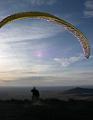
Sunday 1/24/10 Box Canyon Photos
Attached is the link of some photos I took today.
http://s263.photobucket.com/albums/ii13 ... =slideshow
The first half are of mountains around the area and the last half are of Box Canyon.
It was a nice day to get out.
Andy
http://s263.photobucket.com/albums/ii13 ... =slideshow
The first half are of mountains around the area and the last half are of Box Canyon.
It was a nice day to get out.
Andy
Flight Report
<object width="560" height="340"><param name="movie" value="http://www.youtube.com/v/G_PUyv5cicQ&hl ... ram><param name="allowFullScreen" value="true"></param><param name="allowscriptaccess" value="always"></param><embed src="/http://www.youtube.com/v/G_PUyv5cicQ&hl=en_US&fs=1&" type="application/x-shockwave-flash" allowscriptaccess="always" allowfullscreen="true" width="560" height="340"></embed></object>